Step 2: Determine Climate Change Information Needs
Key activities
- Determine why climate change information is needed
- Define the subject of interest
- Determine how the subject of interest reacts to the climate
- Identify the relevant climate variables
- Identify the time frame of interest
- Identify an appropriate time step
- Decide how the information will be found, developed and/or applied
Determine why climate change information is needed
The type of climate change information required depends on the purpose of the activity being undertaken. Climate change information may be needed to:
- assess climate risk
- raise awareness about climate change – in which case broad summary statements or figures about the climate and how it has already changed may be needed, along with some statements about changes that are projected for the future and the possible impacts of these changes.
- show the value of reducing emissions – where climate change projections and impact analyses under different emissions scenarios can be used to show the value of reducing global emissions as part of the ongoing international negotiations following the 2015 Paris Agreement.
When assessing climate risk to plan management or adaptation activities it is important to know key relationships and thresholds of climate variables that affect the things that stakeholders are most concerned about.
For example, taro cultivation in the Pacific has a bio-physical relationship to air temperature. By better understanding this relationship, we could estimate that if the temperature is projected to become too hot (i.e. above 35 °C most of the time) for some areas, there could be a risk that taro cultivation may become uneconomic and therefore may need to relocate to areas that will become more suitable in future.
Define the subject of interest
To focus the development and application of climate change information, clearly define the subject of interest. Answering the following questions will assist in this activity.
- Who needs the information? Is it for a sector (e.g. health, agriculture, water, infrastructure, etc.) or targeted user group (e.g. national or provincial government, or local community group)?
- What boundaries must be considered? Is the information for administrative, legislative or compliance purposes (e.g. national, provincial), environmental (e.g. river basin, national park, marine protected area, etc.), or a planning system (e.g. allocations for an urban water supply system, renewable energy strategy for Nationally Determined Contributions, etc.)?
- What is the planning horizon for which the climate change information is needed? For example, to include climate risks into planning of a new road, bridge or drainage system, climate change projections and impacts on rainfall, river flow and sea level for the next 50 to 100 years may be required.
An important part of this activity is determining a climate change ‘risk’ question. This is equivalent to the ‘hypothesis’ in scientific research. A good question for this purpose is one that is specific and has a clear answer that can be backed up by scientific evidence.
Vague questions or questions without a specific answer are still useful, but only as a starting point. Examples of starting questions are:
- How will climate change affect me?
- Will climate change affect my employment opportunities?
- How bad could climate change be, and could it be good?
- How can we be better prepared?
The answers to these questions are vague and subjective, and may even be more questions! Refining these questions so they are more specific leads to useful questions for a climate risk assessment that addresses climate change impacts. Examples of good questions include:
- Could my island become unsuitable for growing cocoa by 2030 or 2050 if the world follows a high (‘business as usual’) emissions scenario or if we don’t otherwise meet the Paris Agreement targets?
- Is there a higher risk of bleaching to coral reefs from increasing sea surface temperatures and acidification under a high emissions scenario than a low one?
- Is it more likely that impacts from extreme rainfall and/or sea level on coastal communities and infrastructure will increase or decrease under different scenarios?
- How might climate change impact on large-scale natural processes such as the El Niño–Southern Oscillation and associated extreme climate events, and when will these impacts occur?
Determine how the subject of interest reacts to the climate
To identify climate change information that is needed for an assessment, it is necessary to understand the links between the climate and the subject of interest. Conduct a literature review and talk to stakeholders (including experts and traditional knowledge holders) to identify relevant climate variables and any important thresholds, triggers and/or critical ranges for these variables.
Identify the relevant climate variables
Climate variables are the particular factor in nature that we can quantify, measure or model. There are many climate variables, each with their own characteristics and uses. For looking at how the climate affects our lives, the most useful climate variables are those at the Earth’s surface and in the ocean, including standard observations collected by NMHSs and international agencies in the Pacific such as:
- Air temperature (measured at a height of 1.5–2 m at weather stations) – this includes the warmer temperatures during daytime (daily maximum temperature) and the cooler temperature during the night (daily minimum temperature).
- Sea surface temperature – the temperature of the upper layer of the ocean where many plants, animals and coral reefs live.
- Precipitation – a measure of all forms of moisture falling to earth, including drizzle, rain, sleet, snow and hail. In the tropics, we often just refer to rainfall since other forms of precipitation are very rare.
- Wind speed and direction and associated frequency and intensity of tropical storms and cyclones.
- Humidity – both specific humidity (the amount of moisture in the air) and relative humidity (the amount of moisture compared to the maximum that air can hold).
- Sea level – a measure of natural tidal fluctuation.
IMPORTANT: Take care to identify all the relevant variables. For example, when looking at water balance consider run-off and evaporation where available as well as rainfall.
Identify the time frame of interest
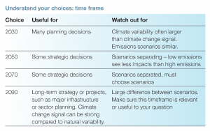
The future time frame that is used should be relevant to an important decision that has to be made.
For example, if a new bridge is intended to last to 2050, changes in the climate by 2050 will need to be considered as part of the engineering specifications.
Even if most decisions are relevant over shorter time frames, a far future time frame may be relevant to a long-term strategy in the sector of interest.
For example, most decisions by farmers about growing crops happen year to year, but it is useful to think about the long-term view about what agriculture may look like for the next generation, such as where and what types of crops will be grown if indeed this may be different from the present in order to respond to an expected change in key agro-met variables such as temperature and rainfall.
IMPORTANT: Make sure the time frame is relevant to your question. For example, to illustrate potential impacts to coral reefs in the next 10 years, climate change by 2090 is not appropriate. Instead, you should use projections to 2030, but also consider natural climate variability over this time period).
IMPORTANT: Do not underestimate the influence of climate variability in the near-term climate. Natural decade-to-decade variability can ‘mask’ the climate change ‘signal’ at timeframes of 10–20 years, so you should carefully examine climate change projections and climate variability when considering this time horizon.
Identify an appropriate time step
The time step is the length of time between values of the climate variable. The main time steps in climate datasets are:
- sub-daily (such as hourly or 3-hourly)
- daily
- monthly
- seasonal
- multi-decadal.
A climate change climatology is the average over a long period such as 30 years or more. Longer time steps or climatologies can be the average value, or other statistics of the climate including for extreme events – for example, for temperature the climatology may be of the average temperature, or the average of the daily maximum temperature, the average daily maximum temperature in July, or even the average of the annual maximum temperature (hottest day of the year) and frequency of drought.
The choice of time step is an important decision when looking at climate analysis. There are two aspects of this decision:
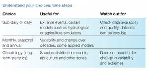
- What time step is most appropriate for your analysis? Sub-daily or daily data are useful for looking at short-lived extremes and are needed for some applied models. Monthly, seasonal and annual data are useful for analysis of variability and change, and are used in some applied models. High-resolution climatology data is used for looking at spatial time slices of climate conditions (e.g. agriculture zones, species distribution modelling, zoning regulations).
- What is available and is it able to be used? Sometimes climate change information or assessment requirements have to be altered depending on what data are available and what you can use. It is necessary to read the relevant data guides and websites on what data are available, how reliable they are, and whether there are any gaps. Daily and hourly datasets can be very large and may require specialised computer skills.

IMPORTANT: Using monthly or annual data doesn’t account for the effect of daily extremes, which might be important in terms of impacts.
Decide how the information will be found, developed and/or applied
Is the climate change information that is required for the assessment already available, or is a new analysis necessary? All key stakeholders should be involved in this decision.
In many cases, existing information can be used for an assessment (see step 3).
If new analysis is required, then it may be necessary to draw on available datasets to develop new climate change information to apply in the risk assessment. Always use the simplest analysis that will do what is needed, and only use complex methods that need complex datasets and analysis if required.
Simple analyses to generate preliminary, application-ready climate change data include applying a change factor to existing observed datasets using the range of projected change in key variables as summarised in the PACCSAP report (steps 3, 4 and 5 provide additional guidance.) More complex methods often require the assistance of technical experts such as climate and crop modellers, hydrological modellers or coastal hazard analysts and data which are often not readily available. (This is further discussed in step 6.)

